Thursday, June 6, 2013

No 90 degree weather.......yet


Louisville has not had a 90 degree day this year.  Last year through today's date, we had already had 4 days in the 90's.
By the end of June 2012, Louisville was up to 17 days in the 90's with 3 days in the 100's.

GFS 500mb June 11
To get several days in the 90's, the 500mb heights need to be at 588 or higher.  You can get 90's below that if the ground is dry or maybe a rapid warmup ahead of a cold front but for an extended hot spell, the higher heights are needed.

For early next week, the core of the heat is over the southern plains and Rockies.


GFS 500mb June 15
By the end of next week, a ridge tries to build into the Ohio Valley so some heat and humidity will build in for the mid-month period......nothing extreme though.


GFS 500mb June 18
By the 18th, the heat ridge will be passing to the east with a lowering of heights to our west.


GFS 500mb June 21
 As we head to the 21st the heat ridge builds over much of the southwest which is the general forecast for the summer.

In past years, in order for Louisville to reach the upper 90's (or higher) the 500mb heights are usually at 594 or higher. Nothing like that is shown at this time.

So based on the GFS, there is a chance for a 90 degree day or two around the 16th or 17th. The current outlook certainly has the temperatures this June a lot more bearable than June of 2012.

Wednesday, June 5, 2013

Water rescues in progress in Birmingham

Updated at 5:00 EDT..... over 3 inches of rain has fallen in Birmingham, AL in 47 minutes resulting in flash flooding.  We are getting reports of some water rescues in progress across the area.

Downtown Birmingham

Birmingham NWS radar


New storms are developing just west of Birmingham. If these move across the city the flooding situation will continue.

Some areas are dry enough to turn on the sprinkler

While there has been talk of all of the rain this spring, there are areas in Kentucky and Indiana that have been dry during the past month.

Officially in Louisville, just over 2 inches of rain has fallen in the last 30 days.  The average amount for that time period is over 4 inches.

At my house in Indiana, we have had less than one inch of rain in the last 30 days and the grass is actually starting to turn brown. I have heard from several people in southern Indiana telling me the same thing. During thunderstorm season, amounts can vary widely over a short distance and it appears that this year is no exception.

Below is the 30 day rainfall and our low local amounts seem to be among the lowest in the region. I hope this is not a sign of things to come.


Summer rain forecast
Climate Prediction Center


The CPC has drought conditions worsening in the high plains over the summer while no real wet or dry signal is seen at this time for the Ohio Valley.


3 day rain forecast
Weather Prediction Center
In the more immediate future, the WPC has about an inch and a half of rain for Louisville.

A tropical system in the Gulf of Mexico will come on shore in Florida with over 4 inches of rain from Tampa to Fort Myers.

2 tornadoes confirmed in Maine

Maine is not a part of the country you think of getting tornadoes. On average the state has 2 tornadoes a year.
That is how many hit Maine on Sunday as a strong cold front moved across New England.
Both were EF-0.
Only some tree damage was reported.

On average, Kentucky gets 21 tornadoes a year. This number was taken from the years 1991-2010. The long term average from 1950 to 1995 had Kentucky with 12 tornadoes a year. More are being reported in recent years. I think a big part of that increase is because of the NEXRAD doppler radar being better able to detect twisters. The NWS in Louisville was a leader in research showing how the small spin-up tornadoes are more common during squall lines than previously estimated. Originally much of this damage was attributed to straight line winds.

Indiana's average is 22 tornadoes.


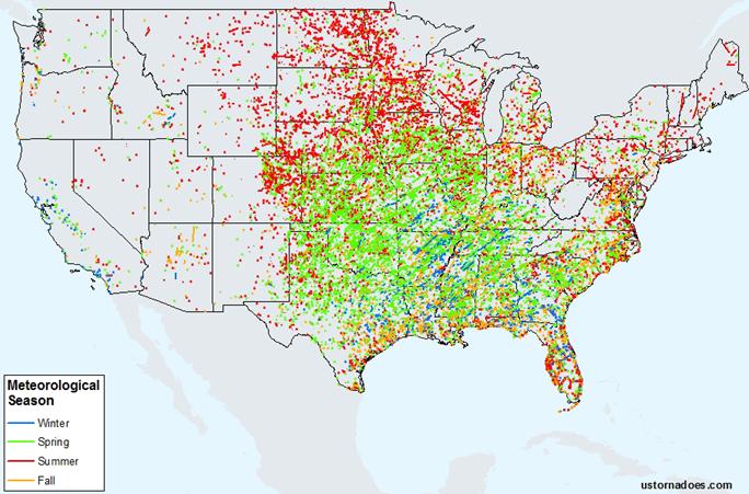
The map below shows the tornadoes over the different seasons. You will notice that all 4 seasons are represented in the Ohio Valley.
Tornadoes by season..... 1991-2010

Tuesday, June 4, 2013

It is snowing in New hampshire

After record high temperatures to start off June, winterlike conditions have returned to the highest mountain in New England.
Mt. Washington with an elevation of 6,288 feet has some of the most extreme weather conditions in the U.S.

At 5:15, the temperature was 31 degrees with a steady wind at 53 mph with gusts over 60 mph.  Snow has been falling off and on during the late afternoon.


To see the current conditions at Mt. Washington.....click HERE

Widest tornado in U.S. history hit Oklahoma on Friday

The tornado that hit El Reno, OK last Friday has been rated at EF-5 and also has been rated with a maximum width of 2.6 miles. This is the widest tornado in U.S. history. This is one of the reasons that traffic and storm chasers had so much trouble getting away from the tornado. The maximum wind speed of the tornado was 295 mph.

This is the second EF-5 tornado to hit the Oklahoma City area during May.

This is the second EF-5 tornado to hit El Reno in 25 months.

El Reno is 28 miles from downtown Oklahoma City.


The early report from the NWS in Oklahoma City lists the following data......
METEOROLOGISTS WITH THE NATIONAL WEATHER SERVICE AND RESEARCHERS FROM
THE UNIVERSITY OF OKLAHOMA CONTINUE TO INVESTIGATE INFORMATION
RELATED TO THE MAY 31 EL RENO TORNADO.

WITH THIS INVESTIGATION... THE TORNADO HAS BEEN UPGRADED TO AN EF5
TORNADO BASED ON VELOCITY DATA FROM THE RESEARCH MOBILE RADAR DATA
FROM THE UNIVERSITY OF OKLAHOMA RAXPOL RADAR. IN ADDITION... THE
WIDTH OF TORNADO WAS MEASURED BY THE MOBILE RADAR DATA TO BE 2.6
MILES AFTER THE TORNADO PASSED EAST OF US HIGHWAY 81 SOUTH OF EL
RENO. THIS WIDTH IS THE WIDTH OF THE TORNADO ITSELF AND DOES NOT
INCLUDE THE DAMAGING STRAIGHT-LINE WINDS NEAR THE TORNADO AS
DETERMINED BY THE HIGH-RESOLUTION MOBILE RADAR DATA. THE 2.6 MILE
TORNADO PATH WIDTH IS BELIEVED TO BE THE WIDEST TORNADO ON RECORD
IN THE UNITED STATES.

.EL RENO TORNADO

RATING:                  EF5
PATH LENGTH /STATUTE/:   16.2 MILES
PATH WIDTH /MAXIMUM/:    2.6 MILES


The tornado that hit Moore was 1.3 miles wide with top winds of 210 mph.

Here is a list of the EF-5 tornadoes in the U.S. during the last 5 years.
2013  El Reno, OK
2013  Moore, OK
2011  Guthrie-El Reno, OK
2011  Joplin, MO
2011  Rainsville, AL
2011  Smithsville, MS
2011  Hackleburg, AL
2011  Philadelphia, MS
2008  Parkersburg, IA

That's 9 EF-5 tornadoes in a 5 year period.
In the 5 years prior to that there were 2 EF-5 tornadoes.
From June 1999 to May 2007 there were no EF-5 tornadoes in the U.S.

40s in some areas this morning

Back after a few days out of town.....  It is not unusual to see temperatures in the 40s the first week of June. It happened last year and it happened in some areas this morning.
In the city, the temperatures stayed in the 50s but outlying locations dipped into the upper 40s.
JEFFERSONTOWN 49
FLOYDS KNOBS 49
LANESVILLE 48

The coldest in Kentucky was 47 at Bardstown and Hawesville.

The coldest in Indiana was 44 near Edinburgh just north of Columbus. Also at Anderson and Laurel.

The latest official temperature in the 40's in Louisville was June 23.

The coldest in the U.S. was 23 at Doe Lake, Michigan.