Wednesday, May 29, 2013

TV station does severe weather coverage from the bathroom

KAMR-TV in Amarillo, TX
Tornado coverage from the bathroom


Last night during storm coverage on KAMR in Amarillo, TX.... a tornado was heading toward the station so the staff headed to safety in the bathroom while continuing the broadcast.
Fortunately, the twister missed the station.

Below is a short video of the coverage......


Severe weather numbers for Friday and Saturday

Friday severe
Storm Prediction Center
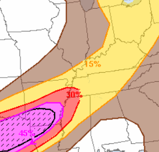
A two day severe weather risk is in the forecast for Friday and Saturday.

On Friday, Louisville is on the eastern edge of the 15% or slight risk for severe storms. The highest risk Friday is from Oklahoma City to St. Louis.

SPC says:  HAIL AND HIGH WINDS WILL BE THE MAIN HAZARDS WITH SOME POTENTIAL FOR AN MCS OR TWO EVOLVING INTO EARLY SATURDAY JUNE 1.

Saturday sever
 For Saturday, the shaded area is the 30% risk for severe which is an upper level slight risk.

SPC says:  EXPECT BANDS OR CLUSTERS OF STORMS CAPABLE OF PRODUCING DAMAGING WINDS TO BE THE MAIN CONCERN.

NWS Louisville says: 
Friday:  Latest guidance depicts some potential in the afternoon, especially if clouds break with lingering mesoscale boundaries across the region.

Saturday:   a nocturnal LLJ of 35-45 knots may aid in storm organization, especially if a strong cold pool can become established in the early evening hours Saturday. So, some strong storms are possible, but will continue to monitor trends for severe potential.

It was a cool spring for Louisville

Updated Wednesday afternoon..... Even though we have had 13 days in the 80's so far this month, it looks like the spring temperatures will end up averaging well below normal.

Meteorological spring goes from March 1 to May 31.

March saw temperatures average a whopping 6.7 degrees below normal.

April averaged 0.4 above normal.

May is averaging 1.0 above normal even though we had our coldest Derby afternoon in 24 years.

The spring season will end up about 5 degrees below normal which is pretty extreme for a seasonal average.

Summer temperature forecast
from the Climate Prediction Center
The summer is forecast to see temps above normal over most of the country according to the CPC.

Forecasts of extreme heat for the plains have been backed down a little due to the recent very wet weather from Texas to South Dakota.


Summer rain forecast
A forecast of dry weather for the high plains will continue the drought (and heat) there.

If the heat ridge develops over the plains it will result in a northwest flow for the Ohio Valley which would mean the heat will be a lot less than last summer.
Also, southeast moving thunderstorm complexes along the edge of the heat ridge would result in an active summer for severe weather. Stay tuned for more on that....


Sunday, May 26, 2013

Incredible snow total for New York

The final snow total for Whiteface Mountain, New York, ended up at
34 inches.


This is the Louisville snow total for the last 2 1/2 winters and they got it all on Memorial Day weekend. Amazing!!!

Saturday, May 25, 2013

18" of snow in New York state

Whiteface Mountain, NY has had 18 inches of snow so far today.

This is in far northern New York state not far from the border with Canada.

Some additional snow is expected tonight in the highest elevations.

When was our last dry weekend

It has not rained so far today at the official weather station at the airport. However, at my house we have had about an hour of very light rain.

The last completely dry weekend in Louisville was April 6 and 7.

This is the 7th weekend in a row with rain in the area. For those areas that have not had any rain yet, there is still a chance for some showers later tonight and on Sunday.

Flash Flood EMERGENCY for San Antonio


A Flash Flood Emergency is in effect until 12:30 CDT for San Antonio, TX. 6-9 inches of rain has fallen this morning. There have been numerous water rescues. One fatality has been reported.


I am not sure how long TV flood coverage will last but here is the link to KSAT..... click  HERE


NWS San Antonio radar
The radar shows the heaviest rains now east of San Antonio.

San Antonio average 32 inches of rain a year. With over 8 inches so far today, they have had over 25% of the annual rainfall in about 4 hours.


 UPDATE....SAN ANTONIO ENDED UP WITH 9.87 INCHES OF RAIN

Friday, May 24, 2013

What the Indianapolis meteorologists are predicting for the Indianapolis 500

Sunday is race day with the Indianapolis 500. Last year the temperature was 91 degrees. It will be a least 20 degrees cooler this year.

For Indianapolis, this is like Kentucky Derby Day..... a very important forecast.

Here is what the TV stations in Indy are forecasting......

WTHR: Rain is likely Saturday through early Sunday morning. The rain will end before the race begins. HIGH 68.


WISH TV: Dry Sunday morning and early afternoon with showers by late afternoon. The rain should hold off until after the race. HIGH 71.


WRTV:  Mostly cloudy for Sunday with a 30% chance for a shower or storm. HIGH 71


WXIN: Mostly cloudy with a chance for a sprinkle or light shower. HIGH 66.  WXIN says it will be the coolest Race Day in 10 years.


NWS forecast......  SUNDAY...MOSTLY CLOUDY. A 30 PERCENT CHANCE OF RAIN SHOWERS IN THE AFTERNOON. HIGHS IN THE MID 60S.


Rare late May frost chance in portions of Kentucky tonight

Updated late Friday afternoon..... Many areas of Kentucky have not had a late May frost since 1961. Most areas tonight will NOT have frost but there could some patchy frost in the valleys along and east of interstate 75.

NWS Louisville says.....  There is some concern for a few patches of frost in the most sheltered valleys and cool spots in the eastern valleys. Most spots will not see frost, so will not continue the special weather statement.


NWS Jackson, KY says....  EXPECTING PATCHY VALLEY FROST ACROSS THE AREA TONIGHT. THE TYPICAL COLD VALLEY LOCATIONS WILL BE ESPECIALLY VULNERABLE...ESPECIALLY IN THE BIG SANDY VALLEY.


Frost ADVISORY in dark blue..... Freeze WARNING in light blue
Issued by the NWS in Charleston, WV
Further to the east the Charleston, WV NWS office has issued a Frost ADVISORY for eastern Kentucky around the Ashland area over into the Charleston area. A Freeze WARNING is in effect for southern and eastern West Virginia including Beckley and Elkins.


In Beckley, the last spring freeze is usually the first week of May. In Elkins, the last spring freeze is usually during the last week in May so tonight's weather there is not that unusual.

Thursday, May 23, 2013

Portland is cool

Lots of people would say Portland, Oregon is a cool city with a great vibe.
The cool we are talking about in this post though concerns the weather.
Yesterday's high of 50 in Portland broke the lowest maximum temperature for the date by a whopping 5 degrees.
Also, it was the third coolest high temperature ever recorded during May in Portland.


Frost and freeze for the north country

 Another blast of cold weather is dropping south out of Canada into the Great Lakes and eastern states.

For tonight, a Freeze Warning is in effect for northern Wisconsin including Rhinelander.
Temps may drop as low as 20 degrees.

The latest spring 20 degrees ever in Louisville was March 31.

A Frost Advisory covers Wisconsin and Michigan including Green Bay and Traverse City

  I spent a few days in the Traverse City area once during the first week of June and the temperature never made it above 50 degrees. So this type of weather can happen this time of year.

Locally, outlying areas will drop into the 40's for Thursday and Friday nights. The Louisville record low for Friday is 40 and for Saturday is 35. Those records are not in jeopardy of being broken.

Wednesday, May 22, 2013

Slide show of the statements and warnings leading up to the Moore tornado

Here is a slide show of the statements and warnings leading up to the Moore, OK tornado. The NWS a week ahead of time was talking about a significant severe weather outbreak.

Check it out..... click  HERE


By the way.... there have been articles and reports talking about little or no warning that the tornado was going to hit. That is totally wrong.

2:40 PM  TORNADO WARNING issued including Moore

3:01 PM  TORNADO EMERGENCY issued for Moore stating that a large, destructive tornado was on the ground.

3:15 PM  Moore is hit by the EF-5 tornado.


Piece of wood through a concrete curb..... Moore, OK

Why do so few homes in Oklahoma City have a basement

I always wondered why there are so few homes with basements in Tornado Alley.

CNN has the answer..... click  HERE

Tuesday, May 21, 2013

Oklahoma City tornado rated EF-5

PUBLIC INFORMATION STATEMENT 
NATIONAL WEATHER SERVICE NORMAN OK 
250 PM CDT TUE MAY 21 2013

...NWS DAMAGE SURVEY FOR 5/20/2013 NEWCASTLE/MOORE TORNADO EVENT - 
UPDATE 3... 

...NWS DAMAGE SURVEY HAS NOW RATED THE NEWCASTLE/MOORE TORNADO AS EF5... 

.OVERVIEW...

THE NATIONAL WEATHER SERVICE DISPATCHED FOUR DAMAGE SURVEY TEAMS TO 
THE PATH OF THE NEWCASTLE/MOORE OK TORNADO. NEW STATEMENTS WILL BE 
ISSUED THROUGHOUT THE DAY AS THESE TEAMS REPORT FINDINGS. THIS 
INFORMATION REMAINS PRELIMINARY AND THE INFORMATION HERE COULD 
CHANGE. 

.NEWCASTLE/MOORE TORNADO  
 
RATING:                  EF5 
ESTIMATED PEAK WIND:     200-210 MPH 
PATH LENGTH /STATUTE/:   17 MILES 
PATH WIDTH /MAXIMUM/:    1.3 MILES 
FATALITIES:              N/A 
INJURIES:                N/A

START DATE:              MAY 20 2013
START TIME:              2:45 PM CDT 
START LOCATION:          4.4 W  NEWCASTLE /GRADY COUNTY /OK
START LAT/LON:           35.2580 / -97.6775

END DATE:                MAY 20 2013
END TIME:                3:35 PM CDT
END LOCATION:            4.8 E OF MOORE OK /CLEVELAND COUNTY /OK
END LAT/LON:             35.3409 / -97.4007
    
SURVEY SUMMARY: EXPERTS SURVEYING IN MOORE HAVE DETERMINED DAMAGE IS 
EF5 WITH MAXIMUM WINDS OVER 200 MPH. FOUR SURVEY TEAMS CONTINUE TO 
INSPECT DAMAGE FROM THIS LONG TRACK TORNADO. INITIAL DAMAGE WAS 
FOUND AROUND 4.4 MILES WEST OF NEWCASTLE...SOUTH OF TECUMSEH ROAD 
ALSO KNOWN AS NW 16TH STREET AND EAST LAKE ROAD. THE TORNADO TRACKED 
NE TO THE INTERSTATE 44 BRIDGE OVER THE CANADIAN RIVER AND THEN TOOK 
A MORE EASTWARD TRACK THROUGH MOORE. TORNADO DAMAGE ABRUPTLY ENDS 
0.3 MILES EAST OF AIR DEPOT ROAD AND N OF SE 134TH ST. 

INITIALLY PRODUCING EF0 AND EF1 DAMAGE THE STORM INTENSIFIED VERY 
RAPIDLY IN 4 MILES OR AROUND 10 MINUTES PRODUCING EF4 DAMAGE BEFORE 
REACHING INTERSTATE 44. NUMEROUS INDICATIONS OF EF4 DAMAGE WITH SOME 
AREAS NOW DETERMINED AT EF5 DAMAGE...THE HIGHEST CATEGORY ON THE EF 
SCALE...WITH OVER 200 MPH WINDS.

ADDITIONAL INFORMATION SUCH AS MAXIMUM PATH WIDTH WILL BE UPDATED
AS THE TEAMS COMPLETE THEIR SURVEYS.
 
The first area listed at EF-5 damage was near Briarwood Elementary School. 

Woman finds her missing dog after tornado during live TV interview

Here are 3 videos of Monday's Moore, Oklahoma tornado.

This first shows the birth of the tornado. The video is 5 minutes long and it is amazing how fast this develops. You go from a funnel cloud to a large on the ground tornado in 5 minutes.

The second video is a time lapse of the tornado from a helicopter.

The third video show a tornado survivor finding their missing dog during a live TV interview. The good stuff starts about 1:20 in.


EF2 in Illinois and severe chances increasing for Louisville


Monday's severe weather reports
There were 23 reports of tornadoes and 263 reports of wind damage on Monday.

Most of the tornadoes were in Oklahoma but one was reported just west of Indianapolis in Hendricks county. It was an EF-0.


Mt. Olive, Illinois
An EF-2 twister was reported at Mt. Olive, IL near Quincy.
The photo shows the damage to Mel's Place. Note the whole upstairs is gone except for the central part.


Wind damage threat through tonight
All of Kentucky has been added to a slight risk for severe for today and tonight. This is mainly an isolated wind damage risk.


Wednesday wind damage risk

For Wednesday, there is an upper level slight risk (30%) for severe storms across Ohio into the Detroit area.


For Louisville, strong storms are possible during the mid-day or afternoon.

How rare is 90 degrees in May

Updated Wednesday morning....  Yesterday's temperatures did not reach the forecast highs in the 90's. It is difficult for 90 degrees mainly do to the lush vegetation this time of the year. However, in the last 3 years, the first hot weather has been arriving earlier.
In the past, in most years, our first 90 degree day in Louisville was the first or second week of June although it has been as late as the last few days of June to get that first 90.

Every date in May except one day has seen 90 degrees at least once over the last 125 years.

Here are the dates of the first 90 degree day of the year.....
2013: none yet
2012: May 25
2011: April 10  This was the earliest 90 degrees ever in Louisville
2010: May 23
2009: June 17

Monday, May 20, 2013

Moore Medical Center damage pic

Here is a pic of the Moore Medical Center after today's tornado.  This kind of looks like the Joplin hospital that got hit by an EF5 tornado a couple years ago. 


Large tornado heading toward Joplin

There is a large, damaging tornado on the ground near Wyandotte, OK moving northeast.  If the storm holds together and continues its present movement, it will pass near or just south of Joplin, MO.

Picture carried 125 miles by tornado

Updated at 7:20 EDT....  Just had a report of a picture from the Moore, OK area carried by the tornado that was found in Broken Arrow, OK..... a distance of about 125 miles.

Moore is a suburb of Oklahoma City and Broken Arrow is a suburb of Tulsa

LIVE updates from Moore, OK major tornado damage

I will post live updates on the tornado in the Oklahoma City area.....

Go to KFOR, KWTV or KOCO for live coverage.

5:45  More than 30 students rescued.... not sure if this is in addition or part of the 75.

5:44 At least 75 children trapped in the school damage.


5:41  KFOR says this may end up being one of the worst tornadoes ever.  Damage looks bad but several hours will be needed to confirm any of this. Our prayers are with all of those facing this extreme situation today.

5:39  Life threatening tornado approaching Talala, OK in the northeast part of the state. 

5:34 Report from the school says students are being pulled out of the school at this time. Confirmed that students were in the school.

5:30  A parent called in to say the school that was hit was on lock-down.  Students were being held at the school until the storm passed. There is no confirmation about anything with the school sice the administration building was also hit by the tornado.

5:20  The Moore tornado has redeveloped east of OKC and a large, bowl shaped tornado near Meeker.

5:19  Large, extremely dangerous tornado heading toward Ramona, OK.

5:18  KFOR says this could be worse than 1999 which was a 1 billion dollar storm.  They are saying it could be the costliest tornado in the world.
Briarwood Elementary School in Moore


5:15  Triage now set up at the IMAX.  More help arriving.

5:15  100 dead horses at a park.

5:13  Many injured people are at the IMAX theater waiting to be treated.

5:11 House fire in Moore. Fire Department has other more important rescues going on right now.

5:09  Large disaster trailer being sent to the staging area.

5:08  Baseball size hail falling in OKC suburbs.

5:06  KFOR comparing this with the Moore, 1999 EF5 tornado. They say this is a larger damage path.

Preliminary damage path for Moore, Oklahoma


5:02  Chopper views showing some structures completely destroyed.

5:01  Damage path appears to be  up to a mile wide at times.

5:00  Staging around at the movie theater parking lot

5:00  Numerous emergency personnel responding

School hit by tornado


4:56   People being extricated from vehicles carries by tornado

4:55  2 schools have been hit with major damage. No other details yet.

More touchdowns in Oklahoma City

Updated at 4:45.... I am watching live tornado coverage on KFOR in Oklahoma City... A school has been destroyed. Not sure if students were inside.  This is in Moore, a southern suburb.

To watch live coverage..... click  HERE

Police scanner traffic does mention a medical facility has been evacuated due to damage.... no injuries, however, walking wounded are showing up to treated.

A Tornado Emergency was issued with this storm.

Many homes destroyed.

A second school has been hit.

Search and rescue headquarters now being set up.

Sunday, May 19, 2013

Oklahoma City tornado pics

I-40 just east of OKC

South side of OKC

Mobile Home Park at Shawnee, OK  east suburb of OKC
It looks like an EF3 or EF4 tornado went through portions of the Oklahoma City area this evening.

Watch tornado coverage from Oklahoma City

Here are the links for the Oklahoma City stations.... there are tornadoes in the area....

KWTV

KOCO

KFOR

3 tornado watches

As of 3:30 PM there are 3 tornado watches in effect.

The northernmost one is for a few tornadoes and thunderstorm winds to 65 mph. This includes Minneapolis.

The second one for Kansas City, Topeka and Wichita is for several tornadoes including a potential for intense tornadoes. Hail up to 3 inches, larger than baseball. Winds over 80 mph.

The southernmost one includes Oklahoma City and Tulsa. This is for several tornadoes with a potential for intense tornadoes. Wind gusts to 80 mph and hail up to 3 inches in diameter.

These watches go into late evening.

SPC severe threat for Monday
The SPC has a moderate risk for severe for Monday in the 45% area.

The main severe threat will be from east of Oklahoma City to Tulsa to Springfield to St. Louis to the Quad Cities.

Severe for Monday


A list of links to watch live tornado coverage

SPC tornado chances for today
Updated Sunday mid-day...... The new severe weather outlook from the SPC keeps a 15% chance of tornadoes for Tulsa into western Missouri.
The area with the hatch marks indicates where there is a chance for EF2 or stronger tornadoes.
This includes...
Tulsa
Kansas City
Joplin, MO

In addition, very large hail  and damaging winds are expected.

Severe weather risk areas


Here is a list of TV web sites where the tornado risk is highest. Some of these sites will have live tornado coverage if something develops in their area.....   Click on the station to go to that web site.

TULSA
KOTV
KJRH
KTUL
KOKI

KANSAS CITY
KCTV
KMBC
KSHB
WDAF


JOPLIN
KOAM
KODE


Saturday, May 18, 2013

Tornado pic from today

This photo was taken in Kansas today.  Looks like a very active day tomorrow.


Anchoarge, Alaska sets a new snow record

Anchorage, Alaska picked up 0.1 inches of snow today. This set a new record for the length of the snow season.
Here is the update from the NWS in Anchorage.....

THE SNOWFALL FROM THE PAST TWO DAYS MAKES 2012-2013 THE LONGEST SNOW SEASON SINCE RECORDS BEGAN IN 1917. THERE WERE 232 DAYS BETWEEN THE FIRST MEASURABLE SNOWFALL (SEPTEMBER 29) AND THE LAST MEASURABLE SNOWFALL (MAY 18). THIS BREAKS THE OLD RECORD OF 230 DAYS SET IN 1981-1982. 


Louisville's snow season this past winter went from December 28 to March 26.... 89 days.

Wrong Preakness winner sent out on text alert

Oxbow won the Preakness Stakes today, but according to this text alert it was Itsmyluckyday, who actually finished second...... OOPS!

Moderate risk for severe for Kansas City, Oklahoma City and Tulsa

Severe weather risk for Sunday
Updated Saturday afternoon.... the Storm Prediction Center has a moderate risk for severe weather (45% area) for Sunday for Oklahoma City, Tulsa and Kansas City.

The hatch marks show where EF2 or stronger tornadoes are possible along with thunderstorm winds above 80 mph.

SPC says:  FORECAST SHEAR PROFILES STRONGLY FAVOR LONG-LIVED SUPERCELLS AND WHERE DEW POINTS HOLD IN THE UPPER 60S/LOWER 70S...TORNADOES CAN BE EXPECTED. GIVEN THE EXPECTED SHEAR/INSTABILITY THERE IS SUPPORT FOR STRONG TORNADOES. ADDITIONALLY...VERY LARGE HAIL SHOULD ACCOMPANY THIS ACTIVITY. MATURING COMPLEX OF STORMS SHOULD PROGRESS ACROSS KS/NERN OK INTO WRN MO WITH MORE SCATTERED ACTIVITY ACROSS CNTRL/SRN OK.

NWS Oklahoma City....  INSTABILITY AND WIND FIELDS WILL BE VERY FAVORABLE FOR HIGH END SEVERE STORMS.

NWS Tulsa....  THE STAGE IS SET FOR A SIGNIFICANT OUTBREAK OF SEVERE WEATHER ACROSS PARTS OF EASTERN OKLAHOMA AND NORTHWEST ARKANSAS LATE SUNDAY...WITH A REPEAT PERFORMANCE IN SOME AREAS MONDAY. ALL MODES OF SEVERE WEATHER WILL BE POSSIBLE WITH SOME HIGH END EVENTS LIKELY.
IT WILL BE A POTENTIALLY DANGEROUS LATE AFTERNOON AND EVENING...ESPECIALLY ALONG AND NORTH OF I-44.


NWS Kansas City....   It still appears that if things were to come together correctly, parts of eastern Kansas and western Missouri could see a line of supercells capable of producing very large hail (baseball-size or larger), damaging winds and tornadoes. Exact tornado threat, and any potential for long-lived strong tornadoes, will depend on the evolution of low-level wind fields and low-level instability which are difficult to get a feel for given the model spread

Tornadoes this year

It has been a quiet year so far for tornadoes..... on a rate for the quietest year in 60 years but that will probably change tomorrow.

Kentucky has had 14 tornadoes this year which is above the annual average of 11.

Kentucky has had more tornadoes than 42 other states.

If you compute number of tornadoes by state area size, Kentucky ranks number 6. Last year Kentucky was number one in the nation.

Indiana has had 4 tornadoes so far this year.

We are almost to the longest day of the year

Updated Saturday afternoon.....   The sunrise in Louisville this morning was at 6:29.  The earliest sunrise of the year is at 6:19 and that will be from  June 9 to June 17.

The sunset this evening is at 8:50. The latest sunset of the year is at 9:10 and that will be from June 21 to July 4.

Barrow, Alaska
At the northernmost city in the U.S., Barrow, Alaska, the sun rose on May 11 and will not set until August 2.

The current temperature in Barrow is 14 degrees with light snow.

The 2 warmest days of the year so far in Barrow have occurred this month..... 34 and 33 degrees for a high.  They have not had a daily low temperature above freezing yet this year.

The current snow depth at Barrow is 4 inches.

Friday, May 17, 2013

Happy Birthday Bill Paxton

 Today is Bill Paxton's 58th birthday.

Star of the 1996 movie, Twister, which was the second highest grossing movie in the U.S. that year.


Indy 500 Pole Day Weather Forecast

I can remember the days when pole day for the Indy 500 used to draw well over 100,000 fans.  The crowds are making a bit of a comeback but it is still not quite that big.

Here is the Indianapolis weather for Pole Day tomorrow and Bubble Day on Sunday.

SATURDAY...MOSTLY CLOUDY WITH CHANCE OF SHOWERS AND ISOLATED THUNDERSTORMS. HIGHS IN THE UPPER 70S. EAST WINDS 5 TO 10 MPH. CHANCE OF PRECIPITATION 50 PERCENT.

SUNDAY...PARTLY CLOUDY. HIGHS IN THE LOWER 80S. SOUTHEAST WINDS AROUND 5 MPH

GFS for Sunday, May 26
 The GFS for race day on May 26 has a ridge building into the area. As long as the deep trough moves to the east coast, then no worries. The problem is that this is a blocking, highly amplified pattern that usually changes slower than what the models indicate 9 to 10 days out.